Everything you need to know about visiting and crossing the Antelope Wells Port of Entry in southwestern New Mexico
When it comes to out of the way towns that I’ve visited so far in New Mexico, Antelope Wells ranks pretty high on the list. Tucked away in New Mexico’s bootheel, Antelope Wells is the southernmost town in New Mexico. It also happens to serve as one of three border crossings between New Mexico and Mexico. Since I like visiting remote places, I decided to check it out. Here’s what I experienced.

Table of Contents
New Mexico Border Crossings
If you’re looking to legally cross the border between New Mexico and Mexico, you have three Ports of Entry to choose from. All three New Mexico Ports of Entry are with the Mexican State of Chihuahua. The most popular crossing is the Santa Teresa Port of Entry, since it’s located 42 miles south of Las Cruces, which happens to be New Mexico’s second largest city (115,303 people). Most people think Santa Fe is New Mexico’s second largest city (89,220 people), but now you know better. The neighboring town in Mexico is San Jerónimo, so you’ll sometimes see the Port of Entry listed as Santa Teresa – San Jerónimo. I’ll be doing a separate blog post about Santa Teresa later this year.
The second Port of Entry, Columbus – Puerto Palomas, is in Columbus, New Mexico. You’ve probably never heard of Columbus since it only has about 1,500 residents. However, it’s located about 32 miles south of Deming (population of ~15,000 people), which you may be familiar with since I-10 passes through the city. Puerto Palomas is the name of the town across the border in Mexico. I’ll cover the Columbus – Puerto Palomas Port of Entry in a separate post.
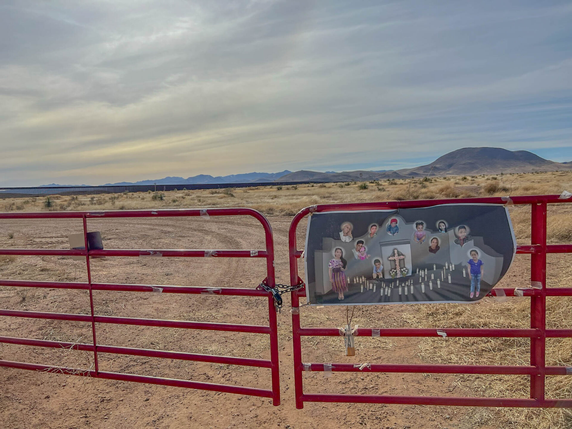
That brings us to the focus of today’s article, Antelope Wells. Antelope Wells – El Berrendo is the third, and least traveled, Port of Entry between New Mexico and Mexico. The closest town in New Mexico is Hachita (population of 52 people) and the closest town in Mexico is Janos (population of 2,738 people). Both towns are located about 45 miles away from Antelope Wells. This post will just highlight what you can expect to encounter if you visit Antelope Wells.

History of Antelope Wells Port of Entry
First things first, you might be wondering about the strange name, Antelope Wells. Apparently, it was named after a local ranch. According to Robert Julyan’s book, The Place Names of New Mexico, Antelope Wells was given its name because there were numerous antelope at a water hole at that location. I suppose both of these name origin stories can be true, so I’ll leave it at that.
Antelope Wells was “settled” in 1847, before President Ulysses S. Grant established Antelope Wells as a border crossing in 1872, but it wasn’t staffed until 1928, four years after the Border patrol was created. I put “settled” in quotes, as it doesn’t sound like many people ever lived here. Today’s estimated population is a whopping 2 people. These U.S. Customs employees live behind the customs station. There’s also a Border Patrol operating base in the area where additional agents stay for a week at a time.
The $11 million dollar facility that you see today was constructed in 2013. On the day I visited, I didn’t see any people outside of the customs building, I didn’t see anyone crossing the border, and I didn’t see any antelope.


U.S. Customs and Border Patrol at Antelope Wells
As I mentioned earlier, Antelope Wells is the least frequented border crossing between New Mexico and Mexico. In fact, Antelope Wells holds the distinction of having the least amount of traffic of any border crossing between the United States and Mexico. After visiting the Antelope Wells, that didn’t surprise me.
How many people cross the Antelope Wells Port of Entry in a typical day?
I spoke with a border guard at Antelope Wells and asked him that question. He said it’s difficult to provide an estimate since it varies widely from day-to-day and month-to-month, and he suggested I contact the U.S. Customs and Border Protection Office of Public Affairs. Which I did. I left a voice mail for the Office of Public Affairs to ask what data they could share and I never heard back from them. I’m guessing they have bigger fish to fry these days when it comes to the topic of the border. If I ever get a response, I’ll update this post, but I’m not holding my breath.
However, I was able to find northbound data from January 2015 – November 2015 posted on-line. The data show a total of 7,798 personally owned vehicles, 1,072 buses, 0 trucks, and 44,889 pedestrians that crossed from Mexico into New Mexico at Antelope Wells during that period of time. That translates to an average of 709 personally owned vehicles per month (~24 cars per day), 97 buses per month (~3 buses per day), and 4,080 pedestrians per month (~136 pedestrians per day). There aren’t any trucks since this Port of Entry is not open for commercial traffic.
I’ve also read that the volume of traffic doubled from 2015 to 2017. In other words, it’s a pretty safe bet that the volume has significantly increased in recent years, but at least those 2015 numbers provide a good reference point.
As for the logistics of crossing the border, the Antelope Wells Port of Entry is open daily from 10am to 4pm Mountain Time. When I showed up, there were no cars or people crossing the border in either direction.
You may need to provide your birth certificate and driver’s license OR your U.S. passport if you’re a U.S. citizen traveling into Mexico. Depending on the duration, location, and type of visit, the cost and other details will vary. Here’s a link to the New Mexico border authority website for the most current information to help you plan your visit.

Things to do in Antelope Wells
Given the lack of people and public facilities at Antelope Wells, the list of things to do is pretty sparse, putting in mildly. It’s a very desolate landscape, but it makes you appreciate the challenges people face when trying to illegally cross the border in this area. There’s also no potable water here, as the local wells contain a bacteria called Legionella which causes Legionnaire’s disease. As a result, the staff need to truck in water to drink, bathe, and clean clothes.
For legal activities, you basically have three options, two of which are blatantly obvious. But one activity might surprise you.
Take a photo at the Antelope Wells border sign
Ok, I know this is a lame activity, but it’s what I ended up doing. First, I parked my car before the border stop sign so that I could take a very unflattering photo in front of the U.S. Customs and Border Protection sign at Antelope Wells, wincing as I looked directly into the sun and wind.

With the awkward photo out of the way, I walked up to the customs building to see if I could find a human being to talk to. After all, one of my requirements for visiting any town in New Mexico is that I need to speak to at least one local.
After several minutes of trying to peer into windows and attract attention, an officer finally came out to see what the heck I wanted. After asking him a border-related question (how many people cross the border and where can I find that data?) and getting nowhere, I tried one other question about an even more remote town in New Mexico called Cloverdale.
Cloverdale is a ghost town with one standing structure, and it’s not easy to get to. Google Maps shows a dirt road that goes from Antelope Wells directly west for what appears to be a 90-minute, very sketchy drive to Cloverdale. I asked the border patrol officer about the drive, and he said it’s not an option. Perhaps he meant that it can be done, but it’s not safe. He told me that the only way to get to Cloverdale is to drive back up to Hachita, go west to Animas, and then take a dirt road south for about an hour. The journey would take 3 hours, and then another hour to circle back north to civilization in Animas, with its population of 237 people. Since it was already getting close to 4pm, I decided that adventure will have to wait for another time.

Cross the border
Yes this second activity is even more obvious. Cross the border. I thought about doing this, but, after meeting the customs officer, I decided against it. It would’ve probably just annoyed him since he would need to process me through the border in both directions, for my amusement. I didn’t get the sense that he would’ve been similarly amused, so I didn’t go there.
Start the adventure of a lifetime: Begin or end a hiking or biking journey on the Continental Divide Trail
You might not have seen that suggestion coming! But it’s true. Antelope Wells has historically served as one of three official starting points, or ending points, for the Continental Divide Trail. The most popular and most official southern terminus is Crazy Cook, which is about 30 miles east of Antelope Wells as the crow flies. The Antelope Wells terminus of the trail is on private property, so it’s no longer a preferred option. However, events such as Tour Divide, a grueling 2,745-mile mountain bike race that starts in Banff, Canada, uses Antelope Wells as the official finish line of the Great Divide Mountain Bike Route. I’ll be covering the Tour Divide and Continental Divide trail in a future post, so I’ll leave it at that for now.
If you want to read what it’s like to hike the Continental Divide Trail, you might want to check out Kyle Rohrig’s book, Chasing Summer on the Continental Divide Trail (Triple Crown Trilogy (AT, PCT, CDT)) or The Continental Divide Trail: Exploring America’s Ridgeline Trail by Barney Mann and Nicholas Kristof.

If you do visit Antelope Wells, I suggest doing it during daylight hours. The risk of encountering wildlife, such as mule deer and rabbits, on the road is much higher during the evening, dawn, and dusk and this is not an area where you’ll want to get in an accident. Plus, you’re more likely to encounter illegal activities in the area in the evening.
Also, keep in mind that the temperature can vary widely at Antelope Wells, with a record high of 109 degrees and a record low of −6 °F (−21.1 °C), so plan accordingly. If you need any supplies or water, you’ll want to buy them at the market in Hachita before driving to Antelope Wells. There’s only one market in Hachita, so it’s easy to find.
Thought for the Week
In a nod to the adventure of hiking or biking the Continental Divide Trail, this week’s quote provides us with an idea for a different adventure challenge that any of us can pursue, starting today. My son and I refer to it as the “Truth Challenge”, and it’s no doubt one of the most challenging and rewarding journeys to undertake.
“If you say the truth, and nothing else, you’ll have an immense adventure as a consequence. You won’t know what’s going to happen to you, and you have to let go of your clinging to the outcome, but the truth will reveal the world the way it’s intended to be revealed, and the consequence for you will be that you’ll have the adventure of your life.“
— Jordan Peterson
Are you up to the challenge?
Thanks for reading and happy travels!
Mark (The New Mexico Travel Guy)

Mark Aspelin, The New Mexico Travel Guy (www.newmexicotravelguy.com), is a travel writer, conservation biologist, project manager, and author of two books. He’s visited over 100 countries and all 50 U.S. states—just enough to land in the Travelers’ Century Club and make choosing a favorite place nearly impossible. He’s currently on a questionable mission to visit every town in New Mexico (there are over 500) and write a story about each one, with plans to wrap it up sometime before his early to mid 100s. Mark balances his writing with conservation and project work from his home base in the East Mountains near Albuquerque, New Mexico.


Leave a reply